Support to space agencies and satellite manufacturers on instrument development and data processing
The observation of the atmosphere from space by microwave radiometers allows a monitoring of all the states of the water : vapour, droplets in clouds, rain, ice … Fluctus SAS offers its experstise in the definition of ground processing and products using the most up-to-date physical and mathematical progress, in-flight calibration, monitoring of the instruments and validation of the products.
Latest News
Fluctus @ OSTST 2019
(October 2019) Fluctus has participated to the 2019 Ocean Surface Topography Meeting at Chicago. Bruno Picard has given 2 talks and collaborated to 1 poster. First talk (download the slides)[…]
Read moreFluctus new logo
Fluctus is all about atmospheric water vapour, clouds, rain and data science. By the way, did you know that Fluctus are relatively short-lived wave formation, usually on the top surface[…]
Read moreFDR4ALT: awarded contract by ESA/ESRIN in CLS consortium
Fluctus SAS has been awarded a contract by ESA/ESRIN in a consortium lead by CLS. Following the successful decades of ERS and Envisat Altimetry mission operations and data exploitation, the[…]
Read moreResearch and Development
GROUND PROCESSING
We have strong expertise on the multiple processing steps from raw instrumental measurement to geophysical products as water vapour and rain rate.
We deliver:-
Studies on the impact of the latest scientific advances
-
Algorith Specification Document,
-
Prototyping of the ground processing
IN-FLIGHT CALIBRATION
The in-flight calibration is a key step for the overall quality of a microwave radiometer. During the first months of the commissionning step, just after launch, the objective is to find the instrumental functioning point that will insure the optimal measurements, comparable to those of current missions.
We deliver:-
Comprehensive assessment of instrument parameters before and after the calibration
-
Vicarious calibration compared to external reference missions
-
Prototyping of the ground processing
INSTRUMENT MONITORING
Instrument life is made of unexpected events and ageing. A responsive monitoring of the key parameters allows a fast detection of any deviation from a nominal behaviour and insures a constant quality over a long-term period
We deliver:
-
Daily monitoring of the key parameters from instrumental measurements to geophysical products
-
Relevant statistics and multiple metrics with extensive graphical representations for expertise review
-
Cyclic report gathering the main events covering the current period
VALIDATION
The performance assessment of an instrumental measurement or a geophysical parameter, wether on its operational or its future version, requires a rigorous and multiple-sources based approach
We deliver:
-
Systematic comparison of brightness temperatures against simulations from Radiative Transfert Model and NWP analysis
-
Systematic comparison to external missions (TB and geophysical products)
-
Systematic comparison of geophysical products to NWP
-
Systematic comparison to geophysical products in-situ measurements (radiosondes,GPS, precipitation radar)
MyWave
Microwave Radiometer SimulatorFluctus SAS is currently developping a generic solution for Microwave Radiometer End-to-end simulators. An end-to-end simulator is a key element in the design of a new instrumental concept. For a microwave radiometer, the two critical parts are the antenna reflector and the radiometric line. Both are tested in the frame of a realistic environment provided by accurate generation of the geophysical situation (scene generator) and detailed simulations of the measurement process (Antenna Processing and Instrument Module). The comparison between the known reference and the output from a ground prototype processing allows to quantify the expected performances of a given design and to verify if the mission requirements are satistified (Performance Analysis).
MyWave will be:
-
Flexible: adaptable to any instrumental concept (CubeSat, Nadir, Imager, Sounder)
-
Realistic: the high-resolution (~ 1 km) geophysical scenes on any surfaces are computed from the combination up-to-date NWP analysis and Radiative Transfert Model
-
Accurate: it benefits from a 15 years experience on every aspects of the end-to-end simulation, including the atmospheric physic, the instrumental measurements principles and the ground processing

Experience
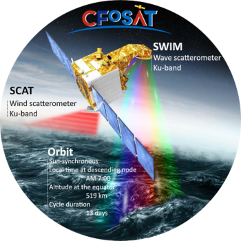
CFOSAT
Support to CLS on the impact of the atmosphere onto the CNES/CNSA CFOSAT/SKIM wave spectra.
Starting in 2018, the CFOSAT satellite’s mission will be to study the characteristics of ocean surface winds and waves. Developed jointly by CNES and the China National Space Administration (CNSA), CFOSAT caries two radar instruments: SWIM (Surface Waves Investigation and Monitoring), a wave scatterometer supplied by CNES; and SCAT (wind SCAT terometer), a wind-field scatterometer supplied by CNSA. SWIM’s 6 rotating beams enables it to measure wave properties (direction, wavelength, etc.), while SCAT measures wind intensity and direction. In this context, Fluctus SAS, in collaboration with CLS MWR team, analyses the impact of the atmosphere (mainly rain) on the quality of SWIM observations and validates potential candidates for rain event flags.

FDR4ALT
Collaboration with Informus in a european consortium lead by CLS.
Following the successful decades of ERS and Envisat Altimetry mission operations and data exploitation, the FDR4ALT project shall revisit the long-standing series of Altimetry observations with the objective of improving the performance of the ESA heritage data sets and their continuity with current and future missions for multi-disciplinary applications and broader data use. In this context, Fluctus SAS in collaboration with Ralf Bennartz and Frank Fell from Informus proposes an intercalibration of the different missions and a reprocessing of the wet tropospheric correction based on a 1DVAR retrieval scheme.


ICARO – Additional studies
Support to Airbus on the design of the next generation of microwave radiometer for coastal altimetry
The “Instrument for Coastal Altimetry Radiometer Observations” ICARO study lead by Airbus for ESA aimed at defining a design for a microwave radiometer suitable for coastal altimetry. In the current context, Fluctus SAS performs additional sensitivity studies on the impact of the spatial resolution or different high frequency observation frequencies on the performance of the wet tropospheric correction performances.
1DVAR Retrieval for Sentinel-3
Collaboration with Informus for Eumetsat on the definition of a wet tropospheric correction for Sentinel-3.
A major source of uncertainty for Sea Surface Height estimates from radar altimetry is the wet tropospheric correction (WTC). The spatial and temporal variability of water vapour is such that an instantaneous estimation of its impact is needed. To provide the observations required for the WTC is the primary role of the nadir looking Microwave Radiometer (MWR) embedded into the altimetry missions on board Sentinel-3. In this context, requirements on accuracy, sensitivity, and long term stability of the atmospheric water vapour observations are particularly strong since altimetry missions require a precision better than 1.4 cm in WTC (RMS) and a temporal stability better than 0.3 mm/year.
In this context, Informus and Fluctus SAS provide scientific development, prototyping, validation and quality definition for Copernicus Sentinel-3 Microwave Radiometer (MWR) Total Column Water Vapour (TCWV), Wet Tropospheric Correction (WTC) and Liquid Water Path (LWP) products. The objective is to implement and validate a 1D-Var retrieval of TCWV, WTC and LWP for Sentinel-3 MWR. The proposed approach will allow for a physical retrieval of the three above properties, including a-posteriori retrieval uncertainties for all parameters.Scientific publications
Peer-review and conference publication list

